check out some of the best hiking trails in ontario
Sault Ste. Marie is the perfect place to visit if you want to enjoy some of the best hiking trail in Ontario. Incredible lookouts, magnificent waterfalls, the rugged Canadian Shield, important historical sites, and clean fresh air with just the sound of the wind in trees or waves on the shoreline… Here are eleven hikes in and around Sault Ste. Marie for you to enjoy.
Hikes within Sault ste. Marie
If you are looking to stay within the city limits then check out these three great trails, perfect for a family hike or if you are looking for a less strenuous trail.
1. The Hub Trail and Fort Creek
Length: 2km – 22.5km
Difficulty: Easy
Must See: Bridges over Fort Creek Conservation Area
If you are looking for a family-friendly hike in Sault Ste. Marie, then the Hub Trail is perfect for you. The trail as a whole is 22.5km of paved path and wooden boardwalk that circles the city.
You can of course choose the section you want to hike and the Fort Creek section is a popular choice for many. The trail takes hikers over three picturesque bridges, where there are lots of opportunity to enjoy the beautiful scenery of the creek below as well as many opportunities to spot all the interesting creatures that live there. Keep an eye out for hawks, great blue herons, and monarch butterflies.
Visit this Hub Trail page for more information including a link to a complete map!
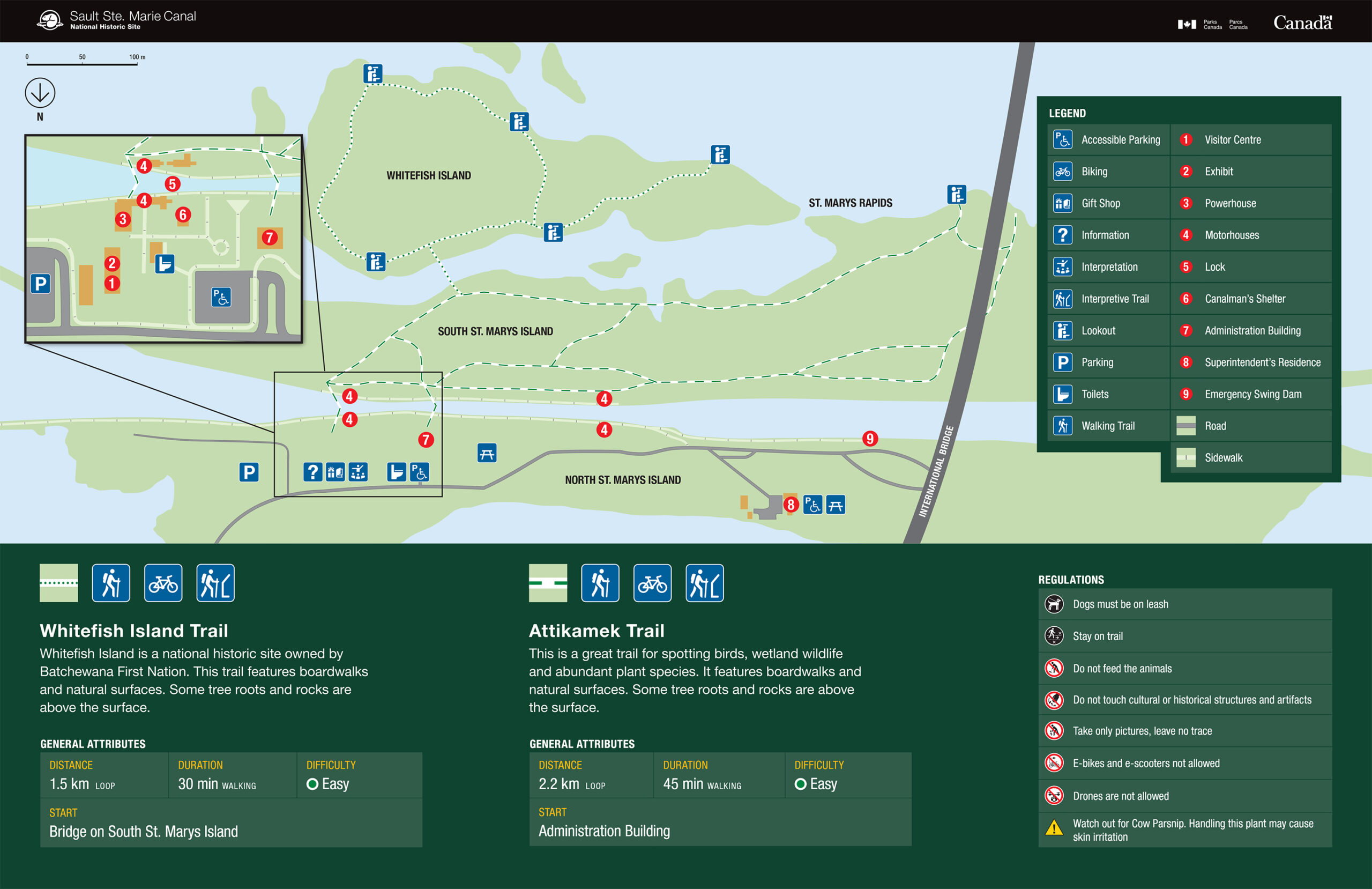
Whitefish Island is a National Historic Site for Canada. It’s also a traditional territory and meeting ground of the Anishinaabe peoples of the Great Lakes due to the abundance of natural resources and fish in the St. Mary’s River.
This site is complete with an easy to follow trail system marked with informational plaques explaining the importance and historical relevance of the island. These trails will lead you through nature preserves right to the historic fishery of the St. Marys River Rapids.
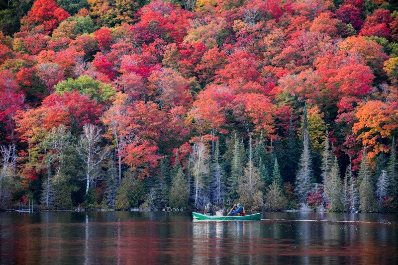
The Voyageur Trail is a public hiking trail consisting of almost 600km of wilderness style trails in Northern Ontario. The Hiawatha Loop (which goes past the stunning Crystal Falls), Odena Loop, Beaver Loop and Mabel Lake Loop make up around 20km of trails in this area.
This there-and-back trail through the beautiful maple forests of the Algoma Highlands takes you to one of best lookout hikes in Ontario. The trail begins at Robertson Cliffs Road and takes you to three incredible south and west facing lookouts. From there you can continue along and do the Robertson Cliffs Loop, passing a beautiful waterfall loop hike, or head back the way you came.
The trails are owned and cared for by Algoma Highlands Conservancy, a not for profit organization that is run by local volunteers. To access maps of the trail system click here.
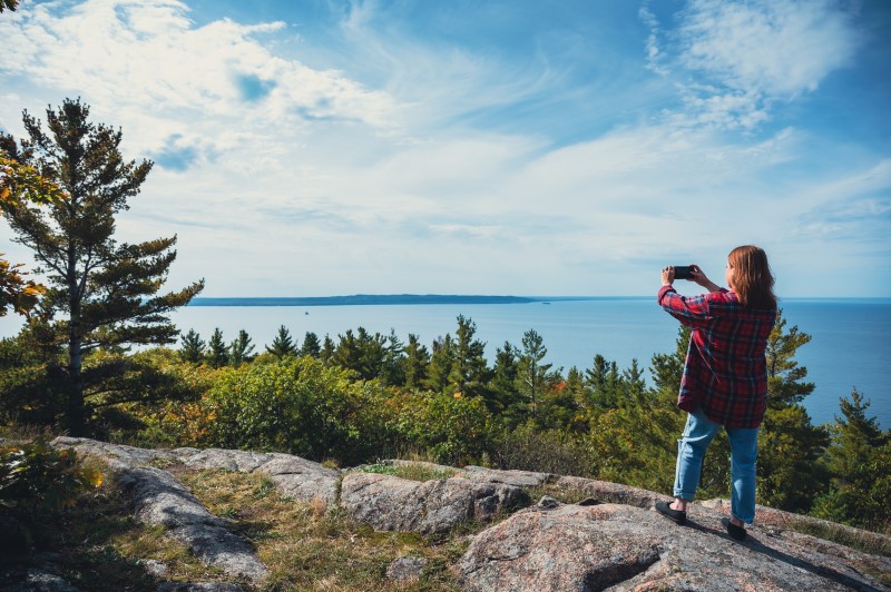
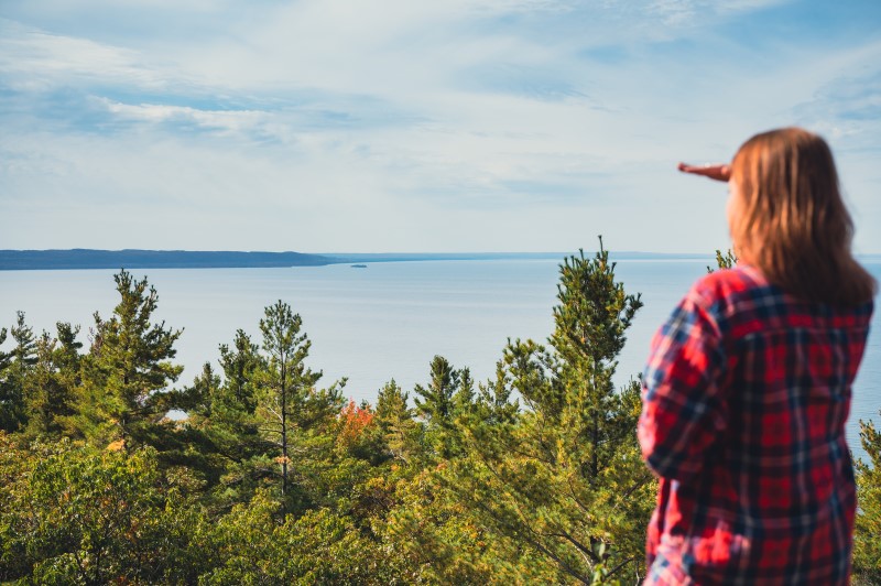
A 30 minute drive north of Sault Ste. Marie takes you to Harmony Beach, where you hike to a spectacular lookout, Eagle Ridge Lookout, overlooking Lake Superior.
Chippewa Falls is a 35-minutes drive north of Sault Ste. Marie, parking and trailhead is right along the Trans Canada Hwy. The falls, which are visible from the highway itself, stand 25 feet high.
The hiking trail offers an easy 2.5km hike to the upper falls, which starts in the parking area and follows the river upstream to the top of the main falls. The path continues alongside the river past the upper falls if you want to explore further.
Chippewa Falls are a stop on the Group of Seven driving tour – the falls and rapids rapids inspired A.Y Jackson’s sketch ‘Stream Bed’. Lookout for a ‘Moments of Algoma’ art easel at the trailhead with more information about the falls and the famous group of artists!
Must See: The unusual smooth rocks overlooking the lake
An beautifully scenic drive east of the city through the Sylvan Valley, and just north of Bruce Mines, takes you to the Rock Lake trailhead. The Rock Lake trail is a offshoot from the Voyageur Trail system, and end up at a unique, smooth rock-top that feels like it should be inspiration for a Group of Seven painting.
Theses smooth rocks face north and lookout over Rock Lake, with an array of maple forests beautifully surrounding it.
The Edmund Fitzgerald lookout trail is another trail with a spectacular lookout. This one overlooks Pancake Bay Provincial Park (in which the trail is situated), Lake Superior and even as far as place where the Edmund Fitzgerald ship tragically sunk in 1975.
The trail system has 3 hikes available; 6km, 10.5km and 13.5km, with the latter hikes taking you to waterfalls and the inland Tower Lakes. For further information click here.
Hikes To The Lake Superior Coast
If you are looking further afield and want to take in all that the Lake Superior coast has to offer, then consider these beautiful hikes.
9. Agawa Rock Pictographs
Length: 1km
Difficulty: Difficult (slippery, steep steps)
Must See: The Sacred Pictographs
At the south end of Lake Superior Provincial Park are the Agawa Rock Pictographs. A clearly marked sign on Highway 17 directs visitors to a parking area at the trail head – map coordinates here.
The Agawa Rock Pictographs is one of the most famous pictograph sites in Canada and is one of the most visited indigenous archaeological sites too. It is a sacred site where generations of Ojibwe have come to record dreams, visions and events. Please respect and preserve the pictographs by not touching the paintings.
For those seeking true adventure, consider this spectacular and rugged coastal trail. It extends from Agawa Bay in the south to Chalfant Cove just north of Warp Bay in the north and will give you a true experience of Lake Superior. Local experts recommend taking 5-6 days because many sections require climbing over rocky headlands and cobble beaches, which can be technically challenging and require a steady pace for safety.
There are various spots for beach camping along the trail; you’ll enjoy incredible coastal scenery during the day and perfectly dark starry skies from your beached-down tent at night.
The Nokomis trail is a 3.8km round-trip lookout hike to overlook Old Woman Bay, in Lake Superior Provincial Park.
The trailhead is across the road from Old Woman Bay Beach parking, and the trail itself takes around 2 hours, with breaks to enjoy the incredible views!
Sault Ste. Marie and the Algoma District have countless hiking trails. Others include Gros Cap, Wishart Park and Odena Lookout, all within the Sault Ste. Marie city limits. The Ojibway Park Nature Trail in Garden River, just to the east of Sault Ste. Marie, is a beautiful ~4km trail that includes a boardwalk out to a lookout area. King Mountain is a great hike and can be reached by continuing your route past Robertson Cliffs. The Orphan Lake trail, in Lake Superior Provincial Park is popular in the summer and fall.
Do you have any other hikes in the area that you particularly enjoy? Tag us in your social media photos #outsideofexpected or our account handles @sault.ste.marie for Instagram and @saulttourism for Facebook. Happy hiking!
By Sault Tourism
adventures just steps away from your hotel or downtown
Sault Ste Marie has a number of well known hiking, lookout and fall-colour viewing areas just outside the city including Robertson Cliffs, King Mountain or Lake Superior. But you actually don’t have to travel as far to see some pretty spectacular sights! You can stay within the city limits and still get lookout views, see incredible waterfalls or enjoy beautiful, glassy in-land lakes.
So keep reading to learn about these mini-urban adventures in Sault Ste. Marie
Crystal Creek Waterfalls: Part 1
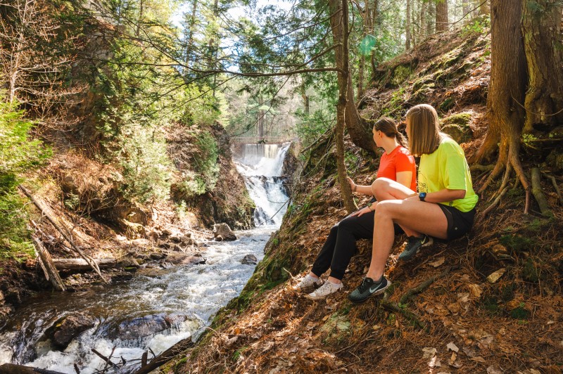
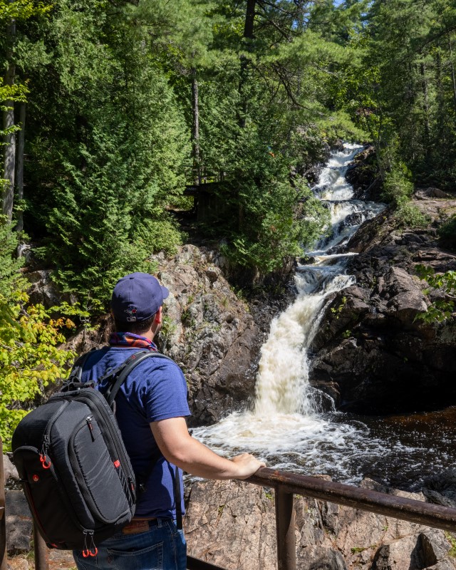
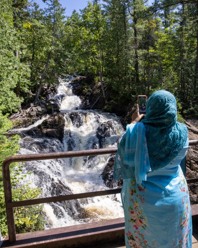
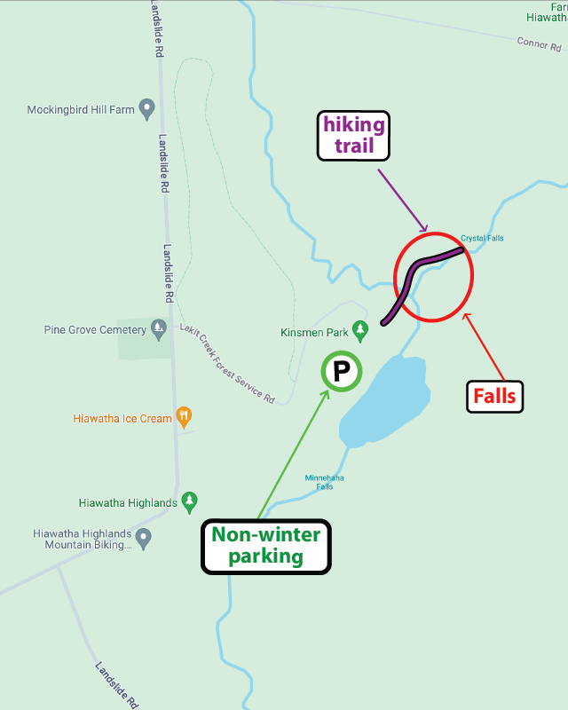
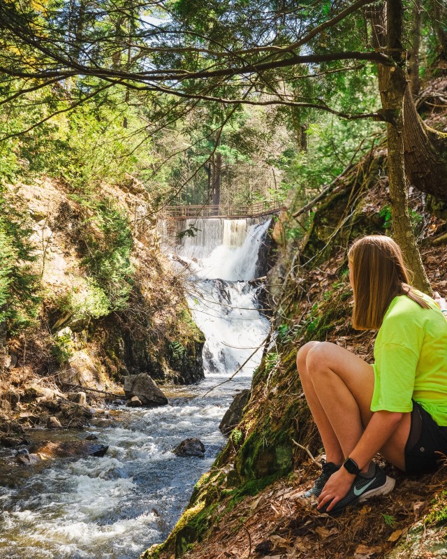
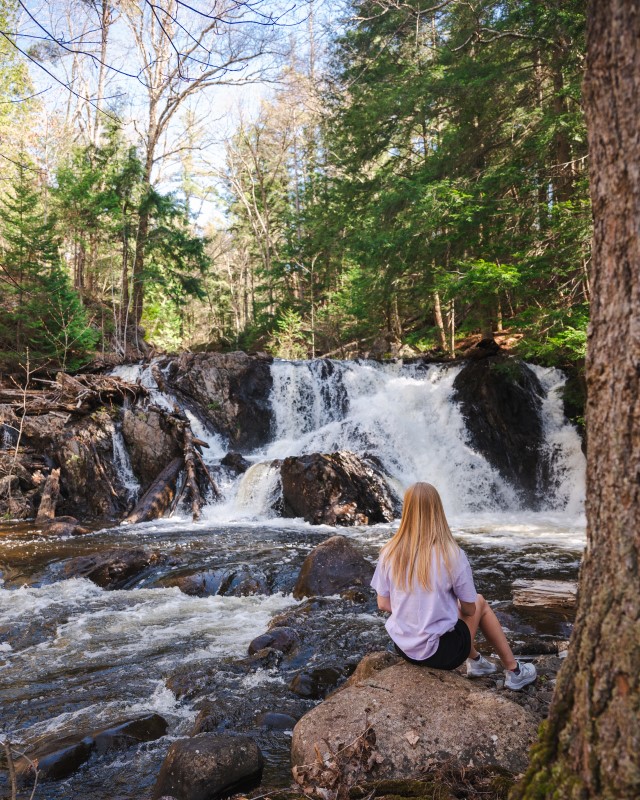
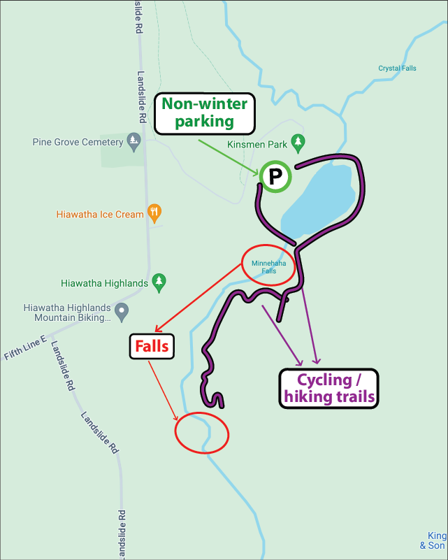
The beautiful Crystal Falls at Kinsmen Park, with a total height of around 80 metres, is one of the most popular visitor spots in Sault Ste. Marie, attracting thousands of visitors each year. Easily accessible from the Kinsmen Park parking lot at Hiawatha Highlands, a boardwalk with handrails leads to the base of the falls with steps leading up to several viewing platforms.
On the other side of Thayer Reservoir, in Kinsmen Park, are the lower Crystal Falls, including the delightfully named Minnehaha Falls. Access to these falls requires a little more work than the higher ones, with some hiking and exploring just off the multi-use cycling/hiking trail TLC, but the rewards are worth it!
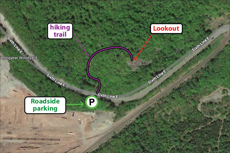
The Odena lookout and Odena Loop at Hiawatha Highlands is part of the Voyageur Trail. The large ‘Loop’ trail is a 4.2km hike that starts at Sixth Line and weaves itself over to Connor Road. Alternatively if you just want to enjoy the incredible view, the Lookout hike is a short 400 metre trot uphill. Once you get to the top the view will take your breath away. Beautiful maple fall colours blended with vibrant coniferous greens make this lookout truly spectacular.
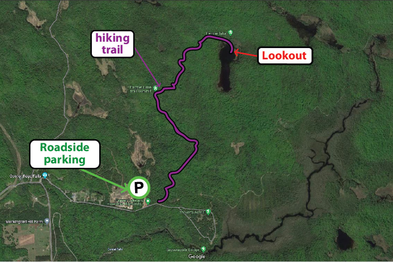
Checkout the Beaver Loop, an out and back 4km loop with a beautiful lookout at Farmer Lake – also part of the Voyageur Trail at Hiawatha Highlands. The trail head is at the end of Connor Road, where there is ample parking, then the trail heads north and east, initially along the route of the Odena Loop before forking off to the right. The trail is a multi-use trail so you’ll find hikers and cyclists alike!
The Attikamek trail on Whitefish Island is a beautiful and easy-paced hike, perfect for enjoying nature. Parking is at the trailhead, located at Sault Ste. Marie Canal National Historic Site, from where you can access the Island across the famous locks. Batchewana First Nation Whitefish Island Reserve is a traditional territory and meeting ground of the Anishinaabe peoples of the Great Lakes due to the abundance of natural resources and fish in the St. Marys River
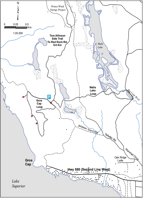
The lookout at Gros Cap Conversation area is another great spot just outside the city limits. While the tree species here don’t offer the vibrant red and oranges of Hiawatha, you can still enjoy fall tones with incredible views of the place where Lake Superior flows into the St. Marys river, the Gros Cap lighthouse, and any Lake Superior ‘lakers’ that happen to be cruising past.
The lookout is part of the Saulteaux-Goulais section of the Voyageur Trail, which leads west and north towards Red Rock.
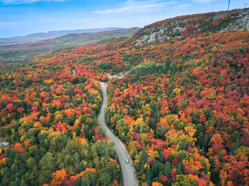
Sault Ste Marie is well-known for its breathtaking beauty during the fall season. Nothing can compare to the vivid colours of the leaves, the numerous trails that can be explored, along with views that will never be forgotten that capture Mother Nature’s true-beauty. From mid-September to mid-October you can find so many ways to enjoy the best of fall in our northern community. In the meantime we have narrowed it down to the top five ways that won’t disappoint!
Come to Sault Ste. Marie and experience Ontario’s awesome fall colours as you’ve never seen them before!
Robertson Lake
1. Ride The Agawa Canyon Tour Train
This attraction is a bucket-list adventure and a big tourist favourite when it comes to seeing the fall colours in its prime. Hop on this day-long journey that starts in our Canal District and travels 114km into the Agawa Canyon; along the way you will be immersed by wilderness and its array of oranges, reds and yellows. Once you reach the Canyon you will get to walk around and explore various trails that will take you to beautiful scenic lookouts and various waterfalls where the Group of Seven once painted some of their iconic paintings. This can’t miss experience will certainly be one for the books!
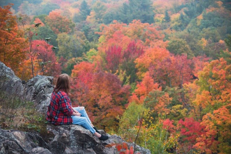
There are so many hikes in and around Sault Ste. Marie that it can be difficult to narrow it down to just one. But if you are only looking to do one hike, try the Robertson Cliffs lookout hike.
To escape to this beautiful scenic lookout, you only need to travel about 20 minutes north of the City. This intermediate hike will not only get your blood flowing but will guide you through the colourful brush and trees. A helpful tip is to make sure you dress accordingly and be prepared to be in awe once you reach the top! When you have completed this 5km hike on Ila’s Trail, you will come upon the breathtaking fall scenery of the boreal forest. You will undoubtedly want to make sure you capture this view with a picture, as the vibrant colours will take your breath away!
You don’t have to venture far to experience what Fall is all about in Sault Ste Marie. Located just north of the city you will find bridges and paths in Kinsmen Park that will take you through a network of trails, such as the Crystal Creek System, where you will see Fall in all its perfection. You can also explore and visit Crystal Falls at one end of the park and then follow the trails to Minnehaha Falls at the other end.
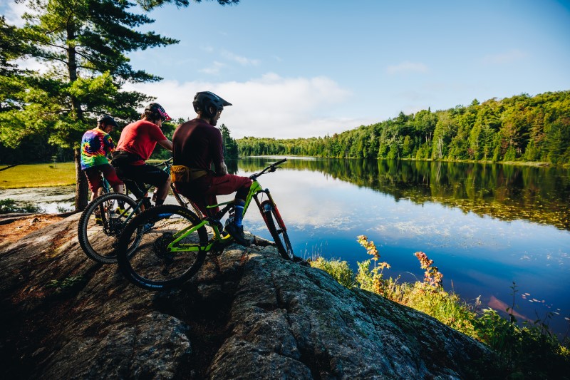
Another must-do fall experience, are the new mountain biking trails located in the same area of the Hiawatha Highlands. Check out fall colours while you enjoy our new flow trails, berms, jumps, techy climbs and more.
4. Check out Fort Creek Conservation Area on the Hub Trail
Enjoy fall in at its best right here in the heart of Sault Ste Marie! The John Roswell Hub Trail is a 22.5km trail that surrounds our beautiful city, with paved paths that you can walk or bike on. One of our favourite parts of the hub trail in the fall specifically, is the Fort Creek section. You can park at the Fort Creek Conservation Area and take the trail through the forest where you will come upon some incredible bridges that overlook the stunning ravine. This simple trail system is nice laid-back one hour walk from the Conversation Area to the Third Line section and back.
5. Take a river cruise on the Miss Marie Sault Lock Tours
Another activity to do in Sault Ste. Marie is take a Sault Locks boat tour. They leave every day until the middle of October at 10am and 1pm. Click here for all the info.
Sault Ste. Marie has excellent, experienced, informative, trained guides to help you get the most out of your time in the city.
Take a day guided tour on the True North Adventure Bus and witness the fall colours you’ve seen on Instagram. Paddle on some of the most beautiful inland lakes in Ontario, and hike to one of best vistas for fall colours anywhere. The True North Adventure bus offers you these experiences. Experienced tour guides Forest The Canoe offer all day adventure tours to some of the most beautiful places in Ontario. Click here to read more.
Go guided with Thrive Tours who offer fall colour hikes, as well as and canoe and kayak tours throughout the Algoma region. Red Pine Tours offer bike tours, Walk Among The Trees specializes in simple, 2- to 3-hour hiking tours sharing Indigenous teachings, culture, ceremony and language. Metis Tours shares Metis history in Sault Ste. Marie and Blaq Bear Tours do culinary and walking tours of the area!
Sault Ste. Marie is a great destination to experience incredible fall colours, with countless other ways to see spectacular reds, oranges and yellows. A scenic drive through the Bellevue Valley to Goulais River is a great way to some stunning colours. Or check out this blog post featuring 4 more ‘unknown’ spots!