Join us at the Canadian Bushplane Heritage Centre for a Thrilling Day of Snowbird-Themed Fun and Entertainment!
By Sault Tourism
The world-famous Snowbirds, the Canadian Forces esteemed air demonstration team, are heading to Sault Ste. Marie, Ontario on Saturday, September 21st, and the Canadian Bushplane Heritage Centre is making a day of it!
Bushplane Days, the annual 2-day celebration, is hosting pre and post-show featuring Snowbird-themed entertainment, plus there will be a designated waterfront viewing area, so you can get front row seats to one of the most anticipated shows in Sault Ste. Marie!
In addition, you can experience the thrill of flying in the Snowbirds yourself via a new virtual reality simulator provided by VSB Foundation, which will be situated in the Museum all day Saturday and Sunday.
Finally, stick around after the show when the pilots will be back in town for an exclusive meet-and-greet at the Canadian Bushplane Heritage Centre.
The Snowbirds
The Snowbirds are the Canadian Forces esteemed air demonstration team and have been operating since the 1970s. They typically fly in formations of 9 aircraft with manoeuvres designed each season and approved by the Canadian Forces. The Snowbirds fly the Canadair CT-114 Tutor, a Canadian-built jet that was used by the Canadian Forces until 2000. The Tutor weighs approximately 7,170 lbs (3,260 kg) and is powered by a J-85 engine producing 2,700 pounds of thrust. Top speeds of the aircraft during the displays range from 100 to 320 knots or 185 to 590 km/h, and the planes fly as close as 1.2 metres to each other!
The Show
The airshow is scheduled to begin at 2pm and will be visible along the Sault Ste. Marie waterfront. The show is designated as a non-aerobatic display. Feel the rumble and immerse yourself in the thrill as the Snowbirds soar and swoop just 500 feet overhead, delivering an unforgettable airshow above the St. Marys River. The show is anticipated to be approximately 30 minutes overhead and will be accompanied by music and live commentary.
Local Connection
The Snowbird Boss (Lead Pilot) is Major Brent Handy, a graduate of Sault College’s aviation program. Major Handy succeeded into the role in of Snowbird 1 for the 2024 season and attended Sault College from 1996 to 1999. In addition, a second pilot flying Snowbird 9 Captain Patrice Powis-Clement, grew up on nearby St. Joseph Island and also graduated from Sault College’s Aviation Technology Flight program.
Major Brent Handy
Captain Patrice Powis-Clement
Saturday, September 21st, 2024
Day 1 of Bushplane Days is dedicated to celebrating aviation history, including the 100th Anniversary of the Canadian Airforce with the Snowbirds airshow. Activities throughout the day will be Snowbird-themed. Doors open at 10am with a variety of family-friendly activities including facepainting, crafts and fun with Entomica creatures.
New this year is the addition of a digital technology company VSB Foundation, who will be offering the very latest virtual reality flight simulator experience. Find out what it feels like to fly with the Snowbirds with this new, fully immersive experience that leverages the latest cutting-edge technology. The VR simulator, will put you in the (virtual) seat of a Snowbird aircraft and will be available at no additional cost, on a first-come, first-served basis during the day.
At lunch time enjoy food from the BBQ, listen to live music and enjoy a specially brewed ‘Tipsy Beaver’ beer by Northern Superior.
Then at 2pm, witness the specular aerial display of the world-famous Snowbirds in a designated, waterfront viewing area on the apron of the Bushplane Museum. Limited seating will be available.
The entertainment continues after the show with more live music, food and drink. At around 4.30pm, you can get a chance to meet the Snowbirds pilots as they head back to the city for an exclusive meet-and-greet at the Canadian Bushplane Heritage Centre.
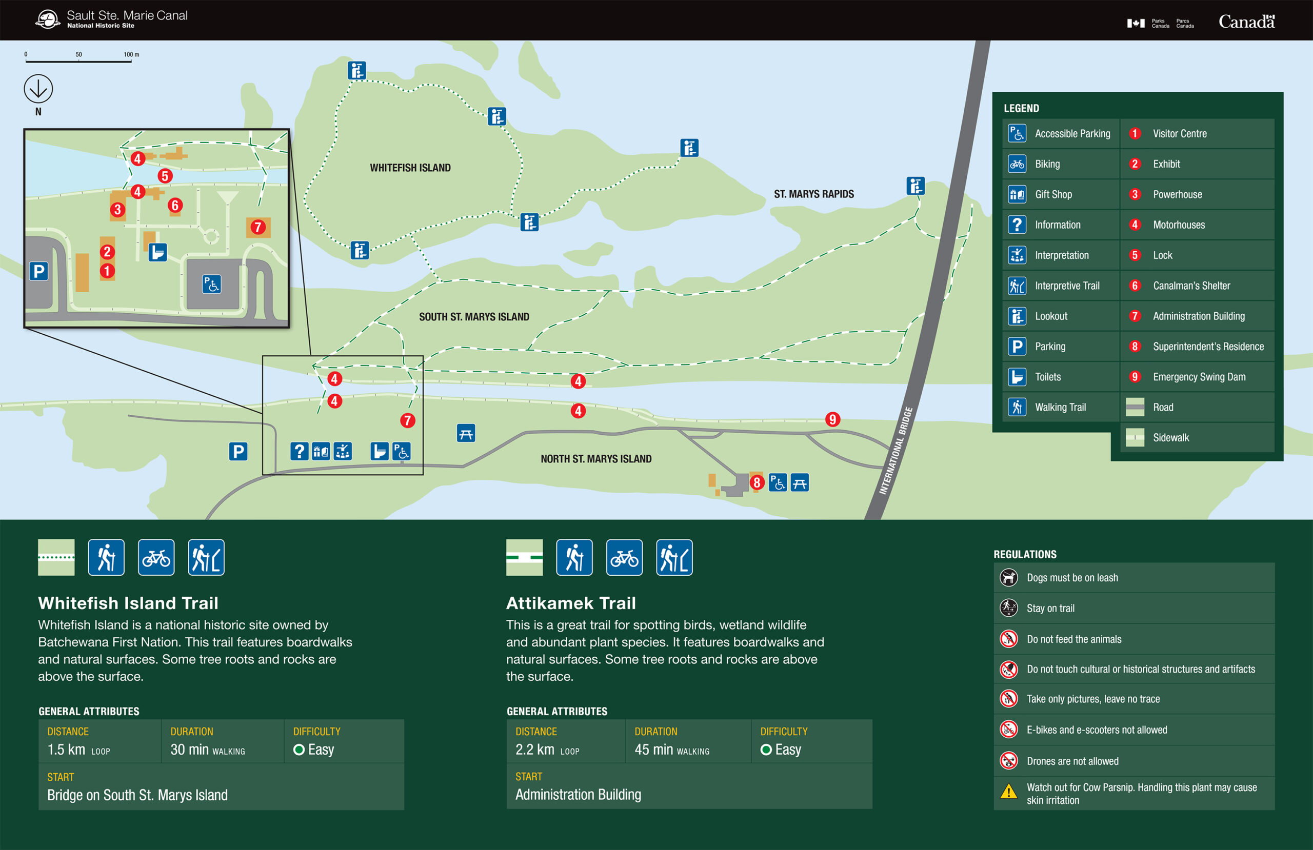
Canadian Bushplane Heritage Centre
VSB Foundation's VR simulator
The pilot's view
Saturday Schedule
10am – Doors open, Bushplane Days begin! Crafts and games, axe throwing, face painting, Snowbirds virtual reality simulator by VSB Foundation
Noon (approx.) – BBQ, beverages and live music
2pm – Snowbirds Aerial Display!
4.30pm to 6pm (approx.) – Meet and greet the Snowbird pilots!
Other Viewing Options
With the airshow spanning the waterfront the best viewing locations will be from the Sault Ste. Marie Canal National Historic Site all the way down to Bellevue Park.
Clergue Park will host the Snowbird’s very own commentator stage. This commentary of the aerial display is a key feature of the Snowbirds routine and will be broadcast on a local FM radio station (to be confirmed closer to the time) so viewers can hear the show from all locations.
The Roberta Bonda Pavilion will also be a great spot to view the Snowbirds and the Miss Marie is running a special Snowbirds tour that day.
The Miss Marie
For a truly unique experience, board the Miss Marie Lock Tour boat for a special Snowbird themed charter on the water, directly below the airshow. Departing at 1pm and returning at 3pm guests can enjoy a river cruise and airshow for $60 per person. Limited tickets available. Appetizers will be served and the charter is fully licensed.
Come down to the Bushplane Museum on Sunday where the fun continues. This year is the 100th anniversary of OPAS (Ontario Provincial Air Service) and there will be celebrations to honor this achievement. More details and exciting announcements to come!
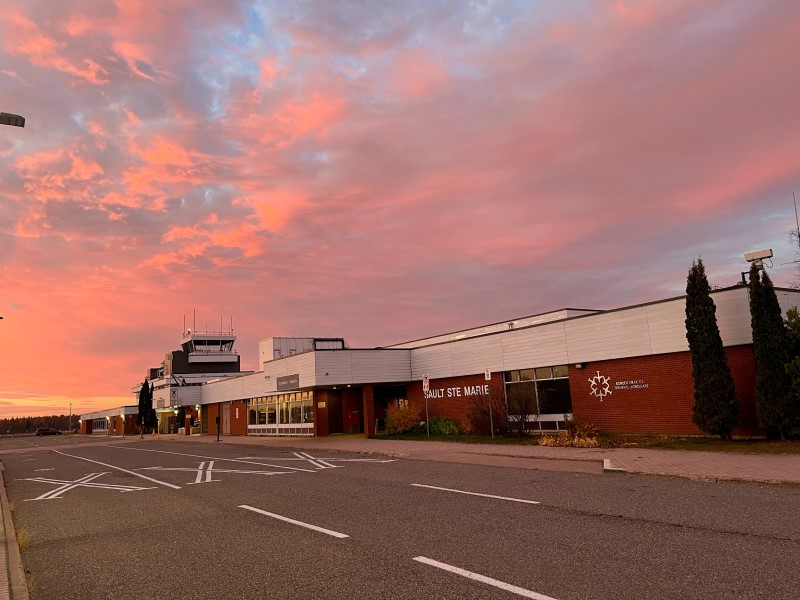
Thanks to the Sault Ste. Marie Airport, for hosting the Snowbirds, as well as providing logistical and technical support. “As the private owner and operator of the Sault Ste. Marie Airport, we see this as a gesture of support for our community and an opportunity to spark interest in aviation across all age groups. This event aligns perfectly with milestones in aviation history, making it especially meaningful for us.” Terry Bos, President and CEO of the Sault Ste. Marie Airport Development Corporation.
By Tourism Sault Ste. Marie
check out some of the best hiking trails in ontario
Sault Ste. Marie is the perfect place to visit if you want to enjoy some of the best hiking trail in Ontario. Incredible lookouts, magnificent waterfalls, the rugged Canadian Shield, important historical sites, and clean fresh air with just the sound of the wind in trees or waves on the shoreline… Here are eleven hikes in and around Sault Ste. Marie for you to enjoy.
Hikes within Sault ste. Marie
If you are looking to stay within the city limits then check out these three great trails, perfect for a family hike or if you are looking for a less strenuous trail.
1. The Hub Trail and Fort Creek
Length: 2km – 22.5km
Difficulty: Easy
Must See: Bridges over Fort Creek Conservation Area
If you are looking for a family-friendly hike in Sault Ste. Marie, then the Hub Trail is perfect for you. The trail as a whole is 22.5km of paved path and wooden boardwalk that circles the city.
You can of course choose the section you want to hike and the Fort Creek section is a popular choice for many. The trail takes hikers over three picturesque bridges, where there are lots of opportunity to enjoy the beautiful scenery of the creek below as well as many opportunities to spot all the interesting creatures that live there. Keep an eye out for hawks, great blue herons, and monarch butterflies.
Visit this Hub Trail page for more information including a link to a complete map!
Whitefish Island is a National Historic Site for Canada. It’s also a traditional territory and meeting ground of the Anishinaabe peoples of the Great Lakes due to the abundance of natural resources and fish in the St. Mary’s River.
This site is complete with an easy to follow trail system marked with informational plaques explaining the importance and historical relevance of the island. These trails will lead you through nature preserves right to the historic fishery of the St. Marys River Rapids.
The Voyageur Trail is a public hiking trail consisting of almost 600km of wilderness style trails in Northern Ontario. The Hiawatha Loop (which goes past the stunning Crystal Falls), Odena Loop, Beaver Loop and Mabel Lake Loop make up around 20km of trails in this area.
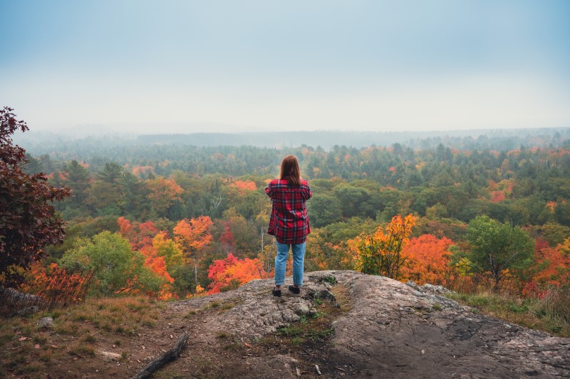
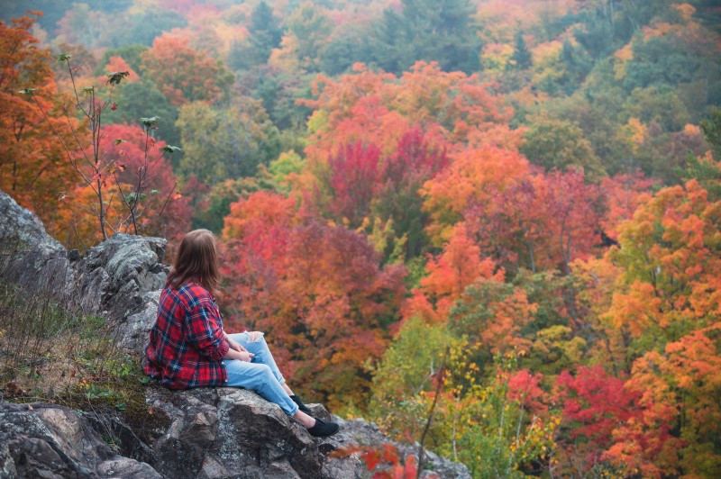
This there-and-back trail through the beautiful maple forests of the Algoma Highlands takes you to one of best lookout hikes in Ontario. The trail begins at Robertson Cliffs Road and takes you to three incredible south and west facing lookouts. From there you can continue along and do the Robertson Cliffs Loop, passing a beautiful waterfall loop hike, or head back the way you came.
The trails are owned and cared for by Algoma Highlands Conservancy, a not for profit organization that is run by local volunteers. To access maps of the trail system click here.
A 30 minute drive north of Sault Ste. Marie takes you to Harmony Beach, where you hike to a spectacular lookout, Eagle Ridge Lookout, overlooking Lake Superior.
Chippewa Falls is a 35-minutes drive north of Sault Ste. Marie, parking and trailhead is right along the Trans Canada Hwy. The falls, which are visible from the highway itself, stand 25 feet high.
The hiking trail offers an easy 2.5km hike to the upper falls, which starts in the parking area and follows the river upstream to the top of the main falls. The path continues alongside the river past the upper falls if you want to explore further.
Chippewa Falls are a stop on the Group of Seven driving tour – the falls and rapids rapids inspired A.Y Jackson’s sketch ‘Stream Bed’. Lookout for a ‘Moments of Algoma’ art easel at the trailhead with more information about the falls and the famous group of artists!
Must See: The unusual smooth rocks overlooking the lake
An beautifully scenic drive east of the city through the Sylvan Valley, and just north of Bruce Mines, takes you to the Rock Lake trailhead. The Rock Lake trail is a offshoot from the Voyageur Trail system, and end up at a unique, smooth rock-top that feels like it should be inspiration for a Group of Seven painting.
Theses smooth rocks face north and lookout over Rock Lake, with an array of maple forests beautifully surrounding it.
The Edmund Fitzgerald lookout trail is another trail with a spectacular lookout. This one overlooks Pancake Bay Provincial Park (in which the trail is situated), Lake Superior and even as far as place where the Edmund Fitzgerald ship tragically sunk in 1975.
The trail system has 3 hikes available; 6km, 10.5km and 13.5km, with the latter hikes taking you to waterfalls and the inland Tower Lakes. For further information click here.
Hikes To The Lake Superior Coast
If you are looking further afield and want to take in all that the Lake Superior coast has to offer, then consider these beautiful hikes.
9. Agawa Rock Pictographs
Length: 1km
Difficulty: Difficult (slippery, steep steps)
Must See: The Sacred Pictographs
At the south end of Lake Superior Provincial Park are the Agawa Rock Pictographs. A clearly marked sign on Highway 17 directs visitors to a parking area at the trail head – map coordinates here.
The Agawa Rock Pictographs is one of the most famous pictograph sites in Canada and is one of the most visited indigenous archaeological sites too. It is a sacred site where generations of Ojibwe have come to record dreams, visions and events. Please respect and preserve the pictographs by not touching the paintings.
For those seeking true adventure, consider this spectacular and rugged coastal trail. It extends from Agawa Bay in the south to Chalfant Cove just north of Warp Bay in the north and will give you a true experience of Lake Superior. Local experts recommend taking 5-6 days because many sections require climbing over rocky headlands and cobble beaches, which can be technically challenging and require a steady pace for safety.
There are various spots for beach camping along the trail; you’ll enjoy incredible coastal scenery during the day and perfectly dark starry skies from your beached-down tent at night.
The Nokomis trail is a 3.8km round-trip lookout hike to overlook Old Woman Bay, in Lake Superior Provincial Park.
The trailhead is across the road from Old Woman Bay Beach parking, and the trail itself takes around 2 hours, with breaks to enjoy the incredible views!
Sault Ste. Marie and the Algoma District have countless hiking trails. Others include Gros Cap, Wishart Park and Odena Lookout, all within the Sault Ste. Marie city limits. The Ojibway Park Nature Trail in Garden River, just to the east of Sault Ste. Marie, is a beautiful ~4km trail that includes a boardwalk out to a lookout area. King Mountain is a great hike and can be reached by continuing your route past Robertson Cliffs. The Orphan Lake trail, in Lake Superior Provincial Park is popular in the summer and fall.
Do you have any other hikes in the area that you particularly enjoy? Tag us in your social media photos #outsideofexpected or our account handles @sault.ste.marie for Instagram and @saulttourism for Facebook. Happy hiking!
Discover Ontario’s best trails at a mountain bike event in Sault Ste. Marie
By Conor Mihell
An epic trail network and incredible terrain is rapidly making Sault Ste. Marie a hub for mountain biking. Ontario cyclists are buzzing about the new trails in the Hiawatha Highlands, only a few minutes north of Sault Ste. Marie’s city centre. Hiawatha has it all: Over 50 km of trails include a mix of impeccably-built, flow trails with fun tabletops and banked corners; old-school, lovingly handbuilt trails with steep drops and rooty climbs; a pump track; and a challenging and scenic backcountry route that blends machine-built features with handmade technical sections.
Three events scheduled for this spring and summer promise to showcase Sault Ste. Marie mountain biking and reveal why this bustling city in Northern Ontario is emerging as one of Ontario’s best cycling destinations.
Skeeter Slam, June 15-16
You may have heard that June is mosquito season in Northern Ontario. But mountain bike competitors at the Ontario Cup races in Sault Ste. Marie will leave biting insects in their slipstreams as they flow along Ontario’s most exciting network of single-track in the Hiawatha Highlands, in the third stage of these province-wide mountain bike events.
Skeeter Slam – Ocup #3, presented by Ontario Cycling and the Sault Cycling Club, is scheduled for June 15-16, and it features something for everyone: a grueling 45-km XC Marathon on Saturday morning, high-speed Short Track racing for all ages on Saturday afternoon, and a full day of OCup age-bracket racing for kids, youth and adults on Sunday.
“The races are open to anyone,” says Travis Anderson, one of the event organizers. “We’re hoping to get people who want to try racing for the first time, all the way up to some of the best up and coming racers in the province—the future World Cup and Olympic racers. We’re really positioning the event as a fun-filled event highlighting our world class trail system, rather than your conventional OCup.”
Hiawatha’s outstanding trails will be the centrepiece of this Ontario mountain bike event. Ontario Cup racers will be challenged by rocky uphills and thrilled by flowing descends. Out of towners will surely fall in love with the area’s wilderness feel—yet it’s so close to great accommodations and dining in Sault Ste. Marie. “I think the new trails are a great fit for the event,” adds Anderson. “They’re the perfect combination of fun, fast and technical with features that you won’t see on any other race courses in Ontario.”
Register online for the 2024 OCup Mountain Bike #3, hosted by the Sault Cycling Club at the Hiawatha Highlands
Salty Marie Trails Festival, July 27
Last year, Sault Ste. Marie cyclist Graham Atkinson and a few friends came up with a clever play on words to name the city’s newest mountain bike event, hosted in the Hiawatha Highlands. The Salty Marie is a nod to “people not being able to pronounce ‘Sault’ Ste. Marie,” Atkinson says. “Turns out ‘salt’ names are also easy to come up with for different races.”
Atkinson was blown away with the support for the inaugural Salty Marie, which attracted over 200 participants last year, including 50 visitors from Ontario and the United States. Registration is already booming for this year’s event, scheduled for July 27, and Atkinson is anticipating an even larger contingent of out-of-towners as Sault Ste. Marie gains recognition as a top destination for mountain biking in Ontario.
“Last year’s success showed us that the city was ready for something like this,” says Atkinson. “This year we’ve decided to double down, and we think a lot of our growth will come from cross-pollination with the OCup races in June and Crank the Shield in August.”
The Salty Marie is equal parts “trails festival” and a “party in the woods,” Atkinson explains. There are multiple mountain bike race options, ranging from the beginner friendly 2 km Saltine Shred to the epic 50 km Big Brine (further evidence that Atkinson and the team of organizers take their salt puns seriously). Mid-distance 10- and 25-km events are also available so anyone can test their limits while having fun. What’s more, you don’t need to be a mountain biker to participate, with 10- and 21-km trail running events also on the schedule.
“It’s a trails festival for everyone,” says Atkinson. “The racers are going to love it, but you can have just as much fun attending as a spectator, with live music, great food, beer and races to watch.”
Register online for the Salty Marie Trails Festival, hosted by Red Pine Tours and the Sault Cycling Club at the Hiawatha Highlands
Racers preparing to race
Winners on the podium
Enjoying some relaxing drinks afterwards!
Crank the Shield, August 16-18
The passion for “adventure cycling” oozing from Sault Ste. Marie native Sean Ruppel is a big reason why the area has become prominent on the Ontario mountain bike map. Ruppel’s 3-day Crank the Shield stage race has earned a reputation for being a seriously challenging mountain bike event, with rugged climbs, river crossings, incredible vistas and the feel of a long-distance adventure race through remote backcountry. Ruppel scoured the Algoma wilderness north of Sault Ste. Marie to weave together Canadian Shield trails, double-track and flowy single-track to create Ontario’s toughest mountain bike event.
Adventure remains a central element of the 2024 Crank the Shield, slated for August 16 to 18. But this time, Ruppel has tweaked the race itinerary with more focus on single-track, creating a more accessible event and taking advantage of the smooth and flowing machine-built Sault Cycling Club trails in the Hiawatha Highlands.
“Crank the Shield opened people’s eyes about the great mountain biking in Northern Ontario,” Ruppel says. “Now it’s time to showcase the great trails that the city has put so much investment into. This year, the pitch is more single track than ever.”
Crank the Shield has always given riders an excellent cross-section of mountain biking in Sault Ste. Marie This year is true to form. Day One follows a 52-km route through the backcountry of Stokely Creek and the Algoma Highlands Conservancy, a wilderness network of single- and double-track with plenty of climbing and hidden swimming holes along the way. Day Two makes a 35-km link from Stokely to Hiawatha, including the challenging handbuilt trails at Bellevue Tower, which ranks amongst the longest downhill single-track for mountain biking in Ontario. Day Three is brand new for Crank the Shield, featuring over 55 km of riding in the Hiawatha Highlands.
Besides running great mountain biking events, Ruppel also knows how to put on a serious party, and apres Crank the Shield doesn’t disappoint with food and beer at the awards ceremony and post-race dinner at the Canadian Bushplane Heritage Museum.
Register online and check out accommodations options for Crank the Shield 2024
Racers at the start line
Racers enjoying the view
Racers on a downhill
Racers on the podium
Make a weekend of it!
Come for a races, stay for the weekend! Enjoy a 90-minute river cruise on the Miss Marie Soo Locks Tour boat! If you are just looking to relax and enjoy some local drinks, check out our own microbrewery Northern Superior.
Check out our famous Bushplane Museum featuring 24 real Bushplanes to explore! Inside the Bushplane Museum you’ll also find Entomica Insectarium, complete with a host of real life insects and bugs you can actually hold!
Have you ever tried axe throwing? Check out one of our newest and most fun indoor activities! Missing golf and still need a fix? The Up and Down Lounge has state of the art golf simulators, which can be booked by the hour.
Get info about hotel stays or any other info by visiting the respective page on our website… and enjoy the races!
By Sault Tourism
adventures just steps away from your hotel or downtown
Sault Ste Marie has a number of well known hiking, lookout and fall-colour viewing areas just outside the city including Robertson Cliffs, King Mountain or Lake Superior. But you actually don’t have to travel as far to see some pretty spectacular sights! You can stay within the city limits and still get lookout views, see incredible waterfalls or enjoy beautiful, glassy in-land lakes.
So keep reading to learn about these mini-urban adventures in Sault Ste. Marie
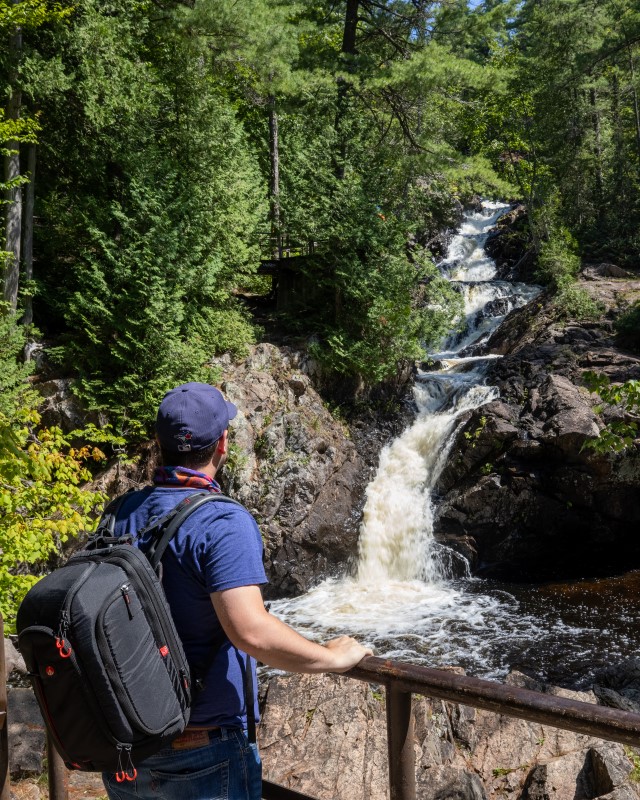
Crystal Creek Waterfalls: Part 1
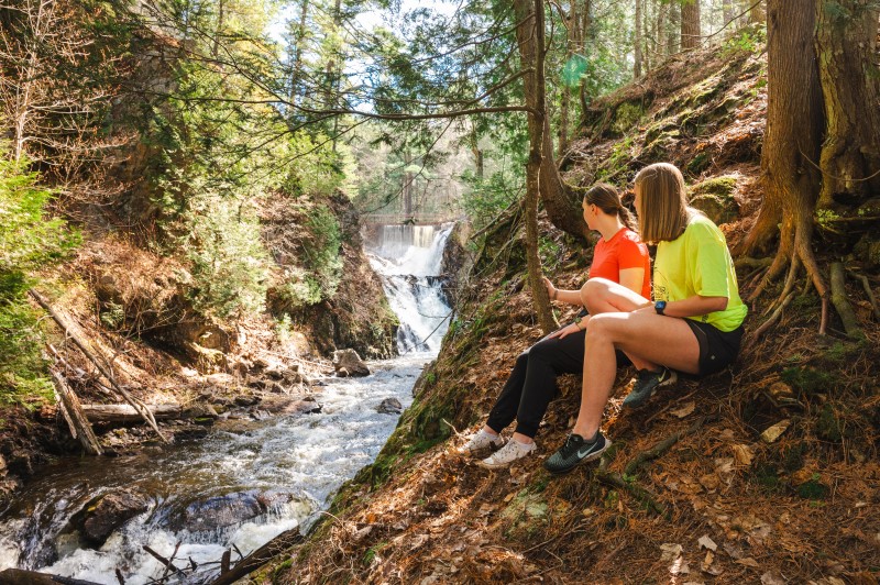
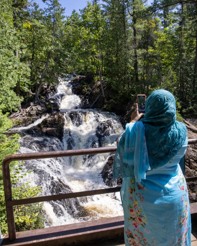
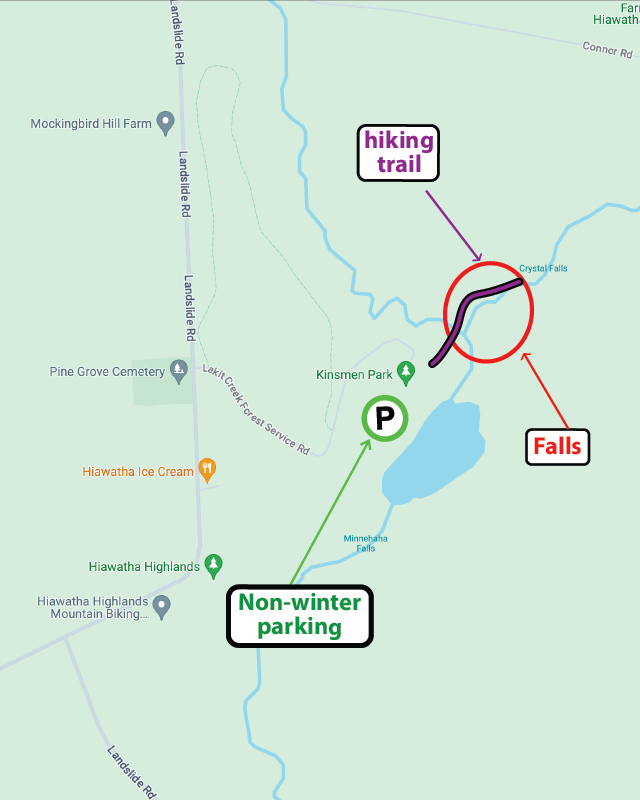
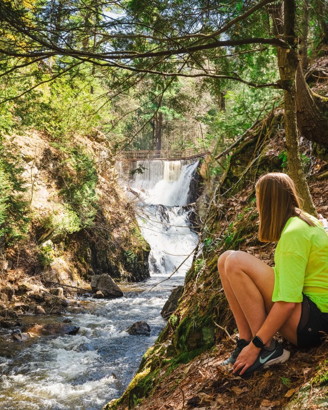
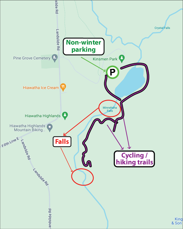
The beautiful Crystal Falls at Kinsmen Park, with a total height of around 80 metres, is one of the most popular visitor spots in Sault Ste. Marie, attracting thousands of visitors each year. Easily accessible from the Kinsmen Park parking lot at Hiawatha Highlands, a boardwalk with handrails leads to the base of the falls with steps leading up to several viewing platforms.
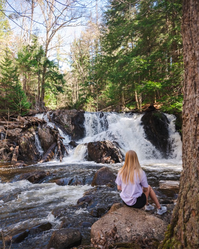
On the other side of Thayer Reservoir, in Kinsmen Park, are the lower Crystal Falls, including the delightfully named Minnehaha Falls. Access to these falls requires a little more work than the higher ones, with some hiking and exploring just off the multi-use cycling/hiking trail TLC, but the rewards are worth it!
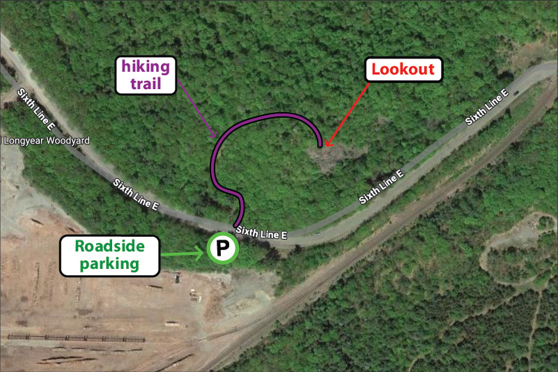
The Odena lookout and Odena Loop at Hiawatha Highlands is part of the Voyageur Trail. The large ‘Loop’ trail is a 4.2km hike that starts at Sixth Line and weaves itself over to Connor Road. Alternatively if you just want to enjoy the incredible view, the Lookout hike is a short 400 metre trot uphill. Once you get to the top the view will take your breath away. Beautiful maple fall colours blended with vibrant coniferous greens make this lookout truly spectacular.
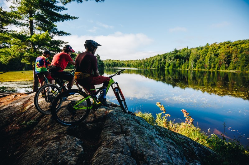
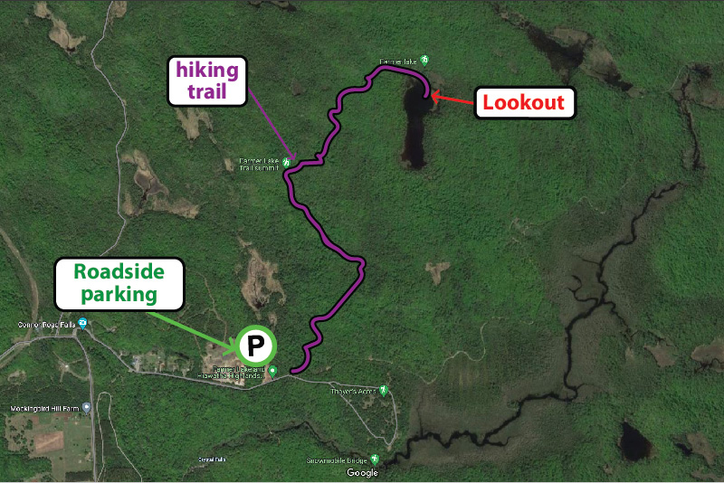
Checkout the Beaver Loop, an out and back 4km loop with a beautiful lookout at Farmer Lake – also part of the Voyageur Trail at Hiawatha Highlands. The trail head is at the end of Connor Road, where there is ample parking, then the trail heads north and east, initially along the route of the Odena Loop before forking off to the right. The trail is a multi-use trail so you’ll find hikers and cyclists alike!
The Attikamek trail on Whitefish Island is a beautiful and easy-paced hike, perfect for enjoying nature. Parking is at the trailhead, located at Sault Ste. Marie Canal National Historic Site, from where you can access the Island across the famous locks. Batchewana First Nation Whitefish Island Reserve is a traditional territory and meeting ground of the Anishinaabe peoples of the Great Lakes due to the abundance of natural resources and fish in the St. Marys River
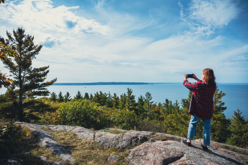
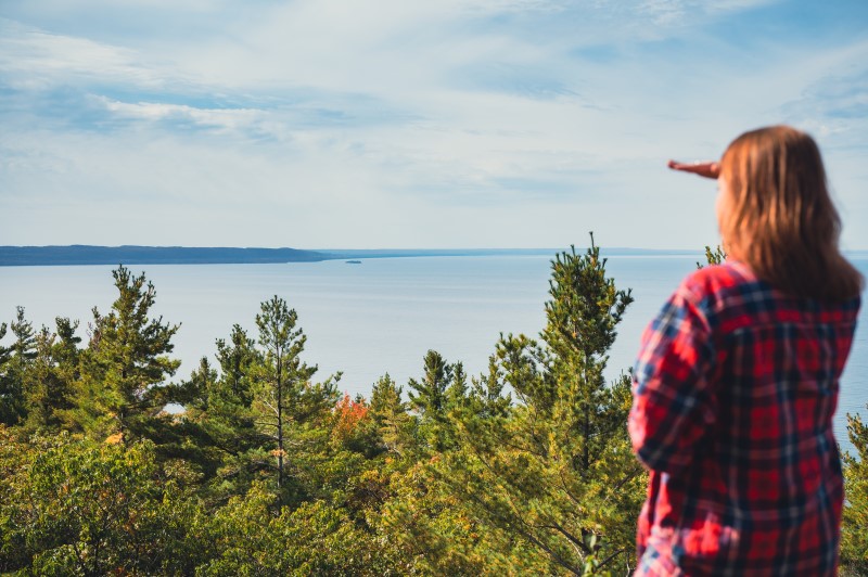
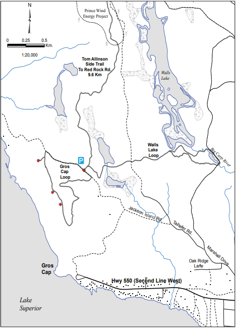
The lookout at Gros Cap Conversation area is another great spot just outside the city limits. While the tree species here don’t offer the vibrant red and oranges of Hiawatha, you can still enjoy fall tones with incredible views of the place where Lake Superior flows into the St. Marys river, the Gros Cap lighthouse, and any Lake Superior ‘lakers’ that happen to be cruising past.
The lookout is part of the Saulteaux-Goulais section of the Voyageur Trail, which leads west and north towards Red Rock.
Take a Daytrip to some of the most beautiful and relaxing sandy beaches in Ontario
Sault Ste. Marie has some of the best sandy beaches in Ontario. Our beaches are incredible! All around our city you’ll find perfectly beautiful, long sandy beaches with crystal clear water that are perfect for a swim, a play in the sand or just to relax and soak up the sun. Great beaches are just one reason Sault Ste. Marie is the perfect place for a summer vacation.
Check out this list of 6 of the best sandy beaches in Ontario, all just a short drive from Sault Ste. Marie. And check out our Summer in the Soo video too!
No.1 – Pancake Bay Provincial Park and beach
A leisurely 45 minute drive north on the Trans-Canada Highway along the stunning Lake Superior coast is Pancake Bay Provincial Park Beach – one of the best sandy beaches in Ontario.
This beautiful area is known for its more than 3 km of golden sand beach and crystal clear, Caribbean blue water. The Edmund Fitzgerald Lookout hiking trail gives an incredible panoramic view of the lake if you are looking for some exercise before relaxing on the sand.
The Park is one of the area’s most popular camping destinations with excellent and comprehensive facilities.
Just south of Pancake Bay lies lies Batchawana Bay Provincial Park, another great Ontario beach on Lake Superior. Batchewana Bay’s sun-soaked, 5 km beach is the perfect place to spend a summer’s day with the family. The water here is shallow, warm and perfect for swimming! Facilities include picnic tables and bathrooms.
Passes for this day-use provincial park can be made online or at the visitor center located on Highway 17.
At the southern end of Lake Superior Provincial Park lies Agawa Bay Beach, a stunning 3km long sandy beach. The water at Agawa Bay can be a little chillier than the more sheltered beaches further south, even at the height of the summer, but this doesn’t impact the natural beauty of shore where stunning hills and cliffs of the Canadian Shield frame the beach on either end.
There are plenty of options for recreational water activities be it paddling, body surfing or swimming. There is also a fantastic visitor centre, featuring stories from Lake Superior and information on local wildlife. Just to north of the Bay is the Agawa Rock Pictographs, one of the most famous Indigenous pictograph sites in Canada.
Agawa Bay is part of Lake Superior Provincial Park, which is one of the largest provincial parks in Ontario. The park boundaries extend north all the way to Wawa, bisected by the Trans Canada Highway. Agawa Bay also has a fully equipped campsite, in case you want to extend your stay. If a daytrip suits you better, then a beautiful 90 minute trip up the Superior coast is a great way to beat the crowds and explore the beauty of Northern Ontario.
Harmony Beach in Haviland Bay is the first beach you will encounter when travelling north on the Trans Canada Highway along the Superior coast from Sault Ste. Marie. This public beach is a local’s favourite, only a half-hour drive from Sault Ste. Marie and featuring 3.2 km of stunning sand and great swimming.
It’s also close to the Haviland Bay Voyageur Trail with stunning views that look out over the lake. So after your hike, take a swim!
Pointe des Chênesis a family-friendly sandy beach in Sault Ste. Marie city limits. This slice of paradise is only a short drive from downtown. It’s the perfect spot for building sandcastles and swimming. Located on Lake Superior at the mouth of the St. Marys River, this great Ontario beach is also an awesome spot to watch the big Great Lakes ships go by.
Peaceful St. Joseph island lies just to the east of Sault Ste. Marie on Lake Huron’s North Channel, off of the Trans Canada Highway. It’s a must-see for visitors, featuring many great Ontario sand beaches. The communities of Hilton Beach and Richards Landing have marinas for boaters, as well as restaurants and shops making it a perfect day trip. Best of all, the island’s wonderful beaches are uncrowded and pristine.
Hilton Beach is home to Forbes Beach and Community Park. This sandy beach features numerous picnic tables, a buoyed swimming area and a raft that swimmers can jump off. Public washrooms, change rooms and playground equipment make this a pleasant destination for an afternoon getaway. The Hilton Beach boardwalk connects the beach to the picturesque marina.
The community of Richards Landing is located on the west side of St. Joseph Island. Women’s Institute Park has a sandy public beach, safe swimming, playground equipment, picnic pavilions and a tennis court. The area is also home to amazing mountain biking and road cycling. Rentals are available at the Richards Landing Marina for those wishing to explore the numerous groomed trails and natural beauty of the island’s forests.
Introducing The Miss Marie Sault Lock Tours Boat, which last year officially launched for its first full year and is back in 2024!
The Miss Marie takes passengers on a 90-minute cruise up and down the picturesque St Marys River. Enjoy the downtown sights of both Canadian and US Sault Ste. Marie, then pass through both set of historic locks and underneath the spectacular International bridge. Wave to Lake Superior ‘lakers’ as well as pleasure boat riders on this famous waterway, or just can sit back and relax and take in the many sights of this beautiful boat ride.
Take a bucket-list train ride
The Agawa Canyon Tour Train is one of North America’s iconic train rides. See the boreal forests, rivers, and waterfalls that inspired Canada’s most iconic artists – the Group of Seven. If traveling in latter part of summer, witness some of the most incredible colours as the maple forests create a stunning palette of reds, oranges and yellows.
This year’s tour season will be from Aug. 1 through Oct. 13. More details on pricing and purchasing tickets can be found on the Agawa train website.
Sault Ste. Marie is the best destination for mountain biking in Ontario. Discover trails for every age, ability or style from jump and flow trails to enduro-style trails carved out of the Canadian Shield. Come and see why Sault Ste. Marie is being called Ontario’s new bike town.
Cradled by the ancient mountains of the Canadian Shield and the biggest fresh water lake in the world, Sault Ste. Marie is Ontario’s best Trail Town.
Hike trails that will lead you to incredible lookout vistas, or along the largest fresh water lake in the world. Or paddle one of our many and varied waterways, from winding rivers to portage-friendly inland lakes, or course the Big Lake, Lake Superior. Whatever your own personal mode of transport is, be it foot or paddle, we’ve got a trail for you.
Sault Ste. Marie has some of the best sandy beaches in Ontario. Our beaches are incredible! All around our city you’ll find perfectly beautiful, long sandy beaches with crystal clear water that are perfect for a swim, a play in the sand or just to relax and soak up the sun. Great beaches are just one reason Sault Ste. Marie is the perfect place for a summer vacation.
Click here to check out 6 of the best sandy beaches in Ontario, all just a short drive from Sault Ste. Marie.
As well as three biking races, we also have a number of running events happening in June; Run The Great Lakes as well as the Community Strong Festival – a series of races over a weekend in June, including a Boston Marathon qualifier!
We also have the Fringe North Festival and an Italian Festival, which are very popular with locals and visitors alike. Stay up to date by visiting our Events page here!
Lake Superior is wild, rugged and beautiful. It can be angry and violent, it can be calm with glassy water reflecting a perfectly clear blue sky. The sunsets can be some of most beautiful anywhere, and the maple forests that hug the coastline put on a fall colour display of bright reds, oranges and yellows so spectacular you’ll be telling your friends for years.
A drive along the coastline from Sault Ste. Marie will let you experience all of this. Get out of your car, RV or motorbike at any of the many stops along the way. Fill your camera up with countless shots of this beautiful coast. Visit in spring, summer, fall or winter for a different experience each season. Be inspired by the incredible Lake Superior coastal drive from Sault Ste. Marie.
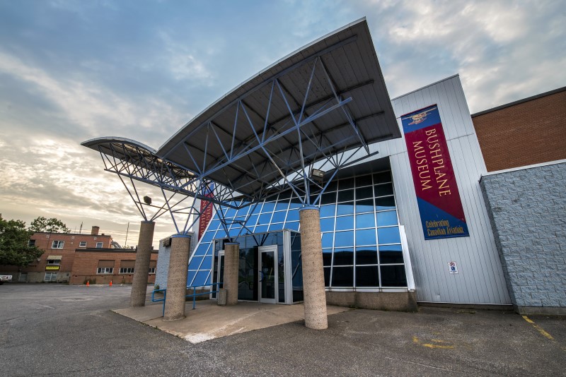
Visit The Bushplane Museum
The Bushplane Museum, or the Canadian Bushplane Heritage Centre to give its full name, is one of Sault Ste. Marie’s top attractions. Perfect for kids to learn about bushplanes, women in aviation, forest fire prevention, plus, kids can run around, climb into planes and have fun exploring. For adults, it’s a museum full of beautiful and fascinating aircraft that shows the important history of bushplanes in Ontario.
Check out Entomica while inside the museum; a wonderful Insectarium where you can meet and hold some pretty interesting creatures!
Traditionally known as Bawating (“the place of the rapids”), Sault Ste. Marie is a place of cultural importance. Follow this long weekend itinerary to experience and learn about Anishinaabe culture in our city.
Thrive Tours offer interpretive eco-tours offering a guided experience of vibrant celebrations of Indigenous life. Metis Tours offer walking and paddling tours that connects historic and community points of interest between the Sault Ste. Marie and and the St. Marys River. Walk Among The Trees specializes in simple, 3 hour walking tours Through an Anishinaabe cultural lens, participants will learn about the natural and cultural history, experience ceremony, storytelling, teachings and cuisine for creating important long-lasting memories
After a day of adventuring you’ll want to refuel and recharge, and we have some great restaurants serving some fantastic food for any taste. From Syrian Shawarma to spicy Indian, delicious Italian or sizzling steak, the Sault has so many great restaurants.
We also brew our own beer! Northern Superior and Outspoken offer craft beers with names including ‘Rabbit’s Foot’, ‘Maglia Rosa’ and ‘Gitche Gumee’. Great beers, great atmosphere equals great times.